ATRAK

Digital Remote Tower
Precision Remote Control for Modern Airspace
Introducing the MAESTRO Digital Remote Tower solution for airports that demand high performance combined with agile scalability. This next-generation air traffic control system represents a new level of digitalization and flexibility in the provision of air navigation services, enabling operations to be delivered from a centralized location, independent of the physical airport site.

Aeronautical Information Management
Reference Point for Aeronautical Information
ATRAK–AIM is ATRAK’s Aeronautical Information Management system that is designed in line with ICAO’s roadmap for transition from AIS to AIM. Its modular design gives you the flexibility to meet your specific requirements of today while allowing for further enhancement and expansion for the requirements of tomorrow. It can achieve the goal of having “message-centric” aeronautical information and “data-centric” aeronautical packages in an integrated solution, whilst distributing the data on a larger scale and increased speed.
ATRAK-AIM services cover preparation, processing and handling of dynamic data (weather and other conditions that impact flight planning and operations) and static data (covering the location and character of navigation aids, distributions the physical characteristics of airports and geography).

Information Data Processing
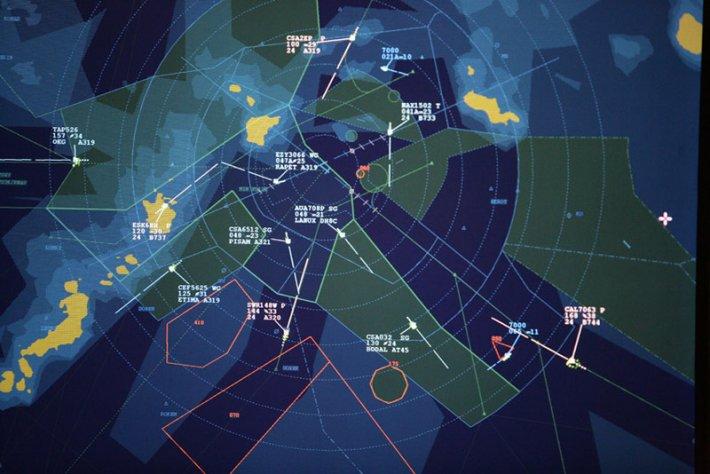
ATRAK-EC/PC processes meteorological data, radar weather information and automated weather-observing system. The Planning control system incorporates EFDM™, Electronic Flight Data Management, a “paperless” functional block environment for the operation of electronic strips. EFDM comprises extended electronic label functionality and tabular flight display information. ATRAK-EC/PC integrates with the ATRAK Aeronautical Information Management system. Both systems can be seamlessly controlled using a single keyboard and mouse. This is known as system interoperability where the mouse cursor can move between the two screens without the need to switch systems.
- A fully functional ATC executive system or as a planning control and fall-back system alongside 3rd party executive systems.
- A fully functional ATC system for the duration of executive system unavailability.
- An integrated part of 3rd party ATM systems, providing Aircraft position and traffic flow display function